


TROPICAL WEATHER OUTLOOK

METEOROLOGICAL SERVICES, MBIA
TIME/DATE: 2:00 pm; Saturday, 22 August 2015
FOR TROPICAL NORTH ATLANTIC OCEAN, CARIBBEAN SEA AND GULF OF MEXICO
AREA OF SPECIAL INTEREST: 10–20°N AND 45–65°W
At 2:00 pm AST (1500 UTC), the center of Hurricane Danny was located near latitude 15.5 North, longitude 52.4 West.
Danny is moving toward the west-northwest near 12 mph (19 km/h). A turn toward the west and an increase in forward speed are expected later today or tonight.
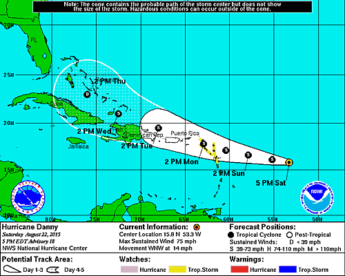
On the forecast track, the center of Danny is expected to be near the Leeward Islands by Sunday night or Monday morning.
Maximum sustained winds have decreased to near 85 mph (135 km/h) with higher gusts. Additional weakening is forecast during the next 48 hours, and Danny is expected to weaken below hurricane strength before it reaches the Leeward Islands.
Hurricane force winds extend outward up to 15 miles (30 km) from the center and tropical storm force winds extend outward up to 60 miles (95 km).
US Air Force Reserve and NOAA Hurricane Hunter aircraft are currently en route to investigate Danny. The estimated minimum central pressure is 985 mb (29.09 inches).
Please note that this system poses no threat to Grenada, Carriacou or Petite Martinique at this time.
Elsewhere…Tropical cyclone formation is not expected during the next 48 hours.