


For Tropical North Atlantic Ocean, Caribbean Sea and Gulf of Mexico

AREA OF SPECIAL INTEREST: 10 – 20 °N AND 45 – 65 °W
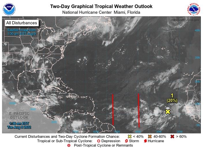
Tropical Wave #1
A western Atlantic tropical wave has its axis near 54°W, extending south of 19°N, approximately 440 nautical miles (nm) east of Grenada. It is moving westward at 15 to 20 kts. Scattered showers are seen from 11°N to 15°N, between 50°W and 57°W. Based on its forward speed and model projections, the axis of this wave should traverse the island chain on Wednesday morning inducing cloudiness and showery activity with a low chance of lightning and thunder if environmental conditions remain favourable.
Tropical Wave #2
A central Atlantic tropical wave has its axis along 43°W, from 20°N southward, approximately 1090 nm east of Grenada. It is moving west around 15 kt. Scattered showers are observed east of the wave axis from 08°N to 17°N between 37°W and 41°W. Based on its forward speed and model projections, the axis of this wave should traverse the island chain on Friday morning. However, models signal that the most active weather will be steered further north of Grenada, across the Central Lesser Antilles. Nevertheless, there is a medium chance of occasional cloudiness and showery activity with a low chance of lightning and thunder on Friday if environmental conditions remain favourable.
Disturbance 1
In the Eastern Tropical Atlantic, shower and thunderstorm activity remains disorganised, associated with a tropical wave located a few hundred miles southwest of the Cabo Verde Islands. While some gradual development of this system is possible over the next several days, environmental conditions are forecast to become less favourable by this weekend. This system is expected to move westward to west-northwestward at 15 to 20 mph across the tropical Atlantic during the next several days. Formation chance through 48 hours, low, 20%. Formation chance through 5 days, low, 30%.
The Meteorological Service will continue to monitor the progress of these systems and provide updates in a timely manner.
Elsewhere, tropical cyclone formation is not expected during the next 2 days.
The next update will be issued at 8 pm.
Eugine Whint, Duty Forecaster