


For Tropical North Atlantic Ocean, Caribbean Sea and Gulf of Mexico

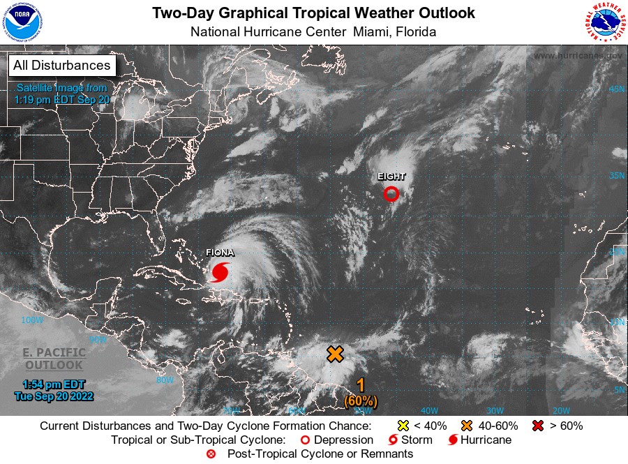
AREA OF SPECIAL INTEREST: 10 – 20 °N AND 45 – 65 °W
Disturbance #1 (orange X):
An Atlantic Ocean tropical wave is along 54°W/55°W, from 14°N southward, approximately 420 nautical miles East of Grenada. This wave is moving westward at 10 knots to 15 knots. At this forward speed, the axis of this wave is expected to traverse the Windward Islands as early as Wednesday afternoon.
Precipitation: scattered moderate to widely scattered strong is from 13°N southward between 50°W and 60°W. Isolated moderate to locally strong is from 10°N to 19°N between 40°W and 50°W. The precipitation pattern has become better organised this morning.
Additional development is expected. It is likely for a tropical depression to form within the next few days, as the system moves westward to west-northwestward through the eastern and central Caribbean Sea. The chance of formation into a tropical cyclone through 48 hours is medium, at 60%. Formation chance through 5 days is high, at 80%.
On Wednesday, this system is expected to bring cloudy conditions with light to moderate scattered showers and a medium chance of thunder to Grenada. Winds are expected to be gusty during showers. There is also a medium chance of flash flooding and/or landslides in areas so prone during heavy showers.
The Meteorological Service will continue to monitor the progress of this system and provide updates in a timely manner.
Elsewhere, tropical cyclone formation is not expected. The next update will be issued at 8 pm.
Eugine Whint, Duty Forecaster