


For Tropical North Atlantic Ocean, Caribbean Sea and Gulf of Mexico

AREA OF SPECIAL INTEREST: 10 – 20 °N AND 45 – 65 °W
Tropical Wave #1
A tropical wave extends its axis along 54-55°W from 24°N southward, approximately 360 nautical miles east of Grenada. This wave is moving W at 15-20 kt. A broad surface trough is associated with this tropical wave. A large plume of atmospheric moisture accompanies this wave between 48°W and 57°W, while Saharan Air dominates the environment between 57° and 62°W. Scattered moderate isolated strong convection is noted from 08.5°N to 15°N between 48°W and 56°W. Based on its forward speed and model projections, the axis of this wave should traverse the island chain Sunday morning. Weather models indicate cloudiness, with light to moderate showers and thunderstorm activity from overnight Saturday and Sunday across the State of Grenada if environmental conditions remain favourable.
The Meteorological Office has issued warnings for a medium chance of flooding and or landslides in vulnerable areas on Sunday and Monday and there is also a small craft advisory in effect.
The Meteorological Service will continue to closely monitor the progress of this waves and provide updates in a timely manner.
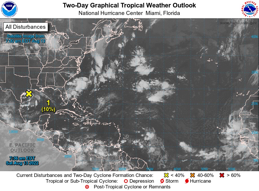
Disturbance 1
Northwestern Gulf of Mexico: A weak low-pressure area located over the northwestern Gulf of Mexico is producing disorganised shower and thunderstorm activity. Only slight development of this system is possible while it moves west-southwestward at 5 to 10 mph and approaches the Texas coast later today and tonight, then moves inland over southern Texas on Sunday. Regardless of development, locally heavy rains are possible along portions of the Texas coast through the weekend. For more information about the potential for heavy rainfall, please see products issued by your local National Weather Service office and the Weather Prediction Center. The reconnaissance aircraft mission scheduled for later today has been cancelled. Formation chance through 48 hours, low, 10 percent. Formation chance through 5 days, low, 10%.
This system poses no threat to the State of Grenada.
Elsewhere, tropical cyclone formation is not expected during the next 2 days.
The next update will be issued at 2 pm.
Eugine Whint, Duty Forecaster